A major renewable energy proposal on the western edge of Glen Innes has officially entered the public exhibition phase, giving residents, neighbouring landholders and local businesses the opportunity to review plans and provide feedback before any determination is made by council.
The Development Application — DA-22-26 / PAN-617188 — has been lodged on behalf of Green Gold Energy Pty Ltd and proposes the construction of a commercial-scale solar installation, an inverter together with an associated eight Battery Energy Storage System (BESS).
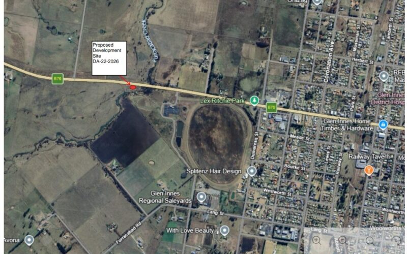
The proposed development site is located along the western approach to town beside the Gwydir Highway, covering Lots 59, 60, 61 and 62 in DP1834, with a smaller section extending toward the corner of Wellingrove Street. Travelling west, the 14ha of land is on the left hand side of the Gwydir Highway, just past the Furracabad Creek bridge.
According to documentation currently on exhibition through https://www.planningportal.nsw.gov.au/daex/exhibition/electricity-generating-facility-495-mw-solar-farm-and-ancillary-bess the proposal includes 10,000 ground-mounted tracking solar panels intended to feed electricity into the adjacent regional power network, together with a dedicated battery storage facility designed to store and release electricity during periods of peak demand. Current estimates are that this is a $6.2M development.
Additional infrastructure proposed for the site includes security fencing, internal access roads, inverter cabins and a six metre wide landscape screening works, to be planted with various native and introduced species.
Project documentation indicates the development would generate a number of temporary construction positions during peak assembly phases, followed by a smaller number of ongoing operational roles once commissioned.
As plans become publicly available, nearby residents and highway users are closely examining how the proposal may affect the western gateway into Glen Innes.
Particular attention is being paid to the site’s topography and the approach from the west along the Gwydir Highway, especially from the West Furracabad Road intersection where the highway descends toward town. Some motorists and landholders are reviewing whether panel location and orientation, reflective glare and tracking movements could impact eastbound traffic approaching over the rise at certain times of the year.
Other areas of local interest include the conversion of 14ha (35 acres) of land historically used for agriculture, the visual impact on the rural landscape, and how the development may integrate with existing farming and agritourism activities in the district.
Formal submissions supporting, objecting to, or commenting on the proposal must be lodged before the close of the public exhibition period on 1 June, 2026 through the Planning Portal or to the General Manager at Council.
A recent guide for biodiversity of solar farms has been published and is available here.